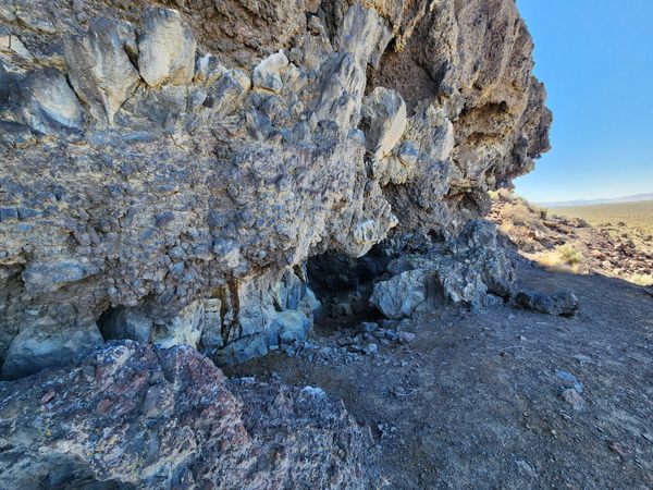
The first arrival of humans in the Americas is traditionally one of the most vexing questions in the archeology of the New World. For decades it was thought that the so-called Clovis culture, named after the area in New Mexico where its artifacts were first documented, was the first. This was a sophisticated hunting culture, characterized by beautifully chipped obsidian spear points, that is widely found across North America. The points are associated with bones of Pleistocene megafauna, suggesting that they were the prey. The most recent evidence indicates the oldest Clovis sites date to about 13,000 years before present (B.P.).
As the Ice Age waned, an ice-free corridor opened between the Cordilleran Ice Sheet on the west, covering the Rocky Mountains, and the Laurentide Ice Sheet on the east. It’s thought that the ancestors of the Clovis people came in through this ice-free corridor while the Bering Strait was still dry land. They would have already honed their hunting skills in Asia.
Other migrants may have come into the Americas as well. For many years reports of pre-Clovis archeological sites were controversial, but it’s now widely accepted that pre-Clovis human occupation occurred. The Paisley Five Mile Caves are now one of the best-documented pre-Clovis sites. This site lies on the east side of Pleistocene Lake Chewaucan, which filled the wide valley east of Winter Ridge. (The modern Summer Lake is a much-shrunken remnant of this ancient body of water.) Surf raised by westerly winds blowing across miles of lake water carved out overhangs and shelters in the shoreline rock. The rock is basalt with intercalated rubble zones and would have been easily eroded by heavy surf.
The Paisley caves contain coprolites—ancient fecal material—that yielded human DNA. Some of this material also yields carbon-14 ages over 14,000 years B.P., over a thousand years before the oldest documented Clovis sites. Although cultural materials such as bone tool fragments, wooden pegs, cordage fragments possibly from mats or baskets, and even fire hearths have been found, there is little evidence of extended habitation. The site seems to have been temporarily occupied, perhaps seasonally when particular resources were abundant.
Know Before You Go
As suggested by their name, the Paisley Five Mile Caves are about 5 miles north of the village of Paisley, on Oregon State Route 31. They can be reached on graded roads, of which the easiest is probably as follows.
From the bridge over the Chewaucan River in Paisley, go north 1 mile on Oregon SR-31 to the intersection with Red House Road (at about 42.70421 N, 120.54869 W) and turn right. Drive 0.3 miles to a graded road entering from the left (at about 42.70569 N, 120.54343 W) and turn left. You will pass a communication tower on the right in about 1.1 miles. Continue another 0.5 miles to where the graded road makes an acute bend to the left (at about 42.72849 N, 120.54333 W); turn to follow this bend about 0.3 miles to another intersection (at about 42.72741 N, 120.54867 W). Turn right here and go 2.2 miles to an intersection (at about 42.75893 N, 120.555837 W) with a primitive road turning right and going up about 650 feet to a big open informal parking area (at about 42.76046 N, 120.55481 W). The caves are visible in the dark outcrop above to the right. There are several use paths up to the caves, and a pretty well-defined use path runs along the front where the caves are, more or less along the ancient shoreline. The area is very rocky with tricky footing, however; be especially careful with children and pets. Also beware of rattlesnakes in the warm months.
This route should be passable to a passenger car in dry weather, but high clearance may be appreciated.
There are no interpretive signs or other identification, but please practice “Leave No Trace” ethics.

